PROCESSING LEVELS

From raw signal to geoinformation

Every level from L0 to L4, taking your data beyond the classical payload ground segment to the higher-order products most systems stop short of.

Talk to us →
RAW TO ENHANCED

Raw input. Reconstructed output.

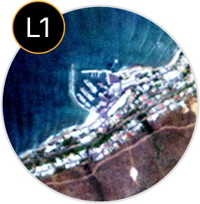
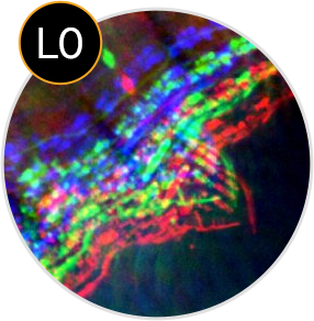
IRMI™ reconstructs, calibrates, and enhances raw scenes so sensor data can move into the higher processing levels with cleaner geometry, radiometry, and visual consistency.

Raw artefacts reduced

Scan lines, band misalignment, blur, and radiometric inconsistencies are corrected where the data supports recovery.

Calibration applied

Raw signal is moved toward calibrated, enhanced imagery with cleaner geometry and radiometry.

Higher levels enabled

Cleaner L1 products support analysis-ready, information, and geoinformation products downstream.

L0 raw scene

Decoded sensor data with scan lines, radiometric inconsistencies, or visible artefacts.

L1 enhanced product

Cleaned, calibrated, and enhanced imagery prepared for downstream processing.

This reconstruction step helps turn imperfect raw inputs into products that can support higher-level analysis and geoinformation.

THE PROCESSING LADDER

Most ground segments stop near L1. The value sits higher up.

IRMI™ carries mission data from raw sensor output through calibration, analysis-ready products, information products, and live geoinformation services.
Raw sensor data

Unprocessed satellite payload data.

Calibrated and enhanced

Radiometric, geometric, enhanced, and orthorectified imagery.
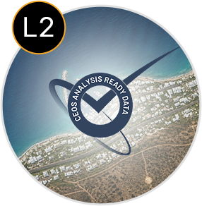
Beyond CEOS ARD

Surface reflectance, BRDF normalisation, and topographic correction.
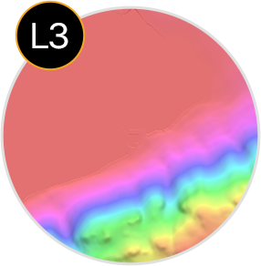
Information products

Mosaics, surface models, indices, data-cube products, and derived measurements.

Geoinformation and notifications

Civil monitoring products, event services, and user-defined alerts.

Most ground segments stop near L1

L0 and L1 prepare and correct the data.

The value sits higher up

L2, L3, and L4 create the higher-order products.


Most ground segments stop near L1.

The value sits higher up.
PRODUCT CATALOGUE

Processing levels, product by product

A technical catalog of outputs across the full chain from raw sensor data to higher-order geoinformation products.

Level 0, raw sensor data

Decoded and reformatted raw downlink with quality flags and STAC metadata. Not intended for general use.

Code
Product
Description
Code L0
Product Raw sensor data
Description Decoded and reformatted downlink with telemetry-error flags and STAC metadata. The input to all higher levels; not for general use.

Level 1, calibrated, enhanced, orthorectified

Radiometric calibration, geometric correction, enhancement, and orthorectification move raw sensor data toward usable imagery for analysis and mapping.

Code
Product
Description
Code L1A
Product Radiometric calibration
Description Radiometric calibration applied, including flat-field correction and digital number to relative radiance, in raw sensor geometry.
Code L1B
Product Geometric correction
Description Rectified to an ideal sensor geometry described by a single RPC, with options for pan-sharpening, single-image super-resolution, bundle adjustment, and band-to-band registration.
Code L1C / L1T
Product Orthorectified, systematic
Description Terrain-corrected imagery without ground control, or with a global reference and ground control points.
Code L1Ca
Product Orthorectified, local reference
Description Orthorectified imagery using a local reference with ground control points.
Code L1Cb
Product Standard ortho
Description Orthorectified imagery using a global DEM.
Code L1Cc
Product Precision ortho
Description Orthorectified imagery using a local DEM.
Code L1Cd
Product True ortho
Description Orthorectified imagery using 3D building models, pan-sharpened, with options for bundle adjustment and single-image super-resolution.
Code L1CalVal
Product Calibration and validation
Description L0-derived geometric, spatial, radiometric, and spectral characterisation, with an auto-generated report.
Beyond CEOS ARD

Level 2, atmospheric and ARD

Atmospheric correction moves calibrated imagery toward analysis-ready surface products, with BRDF normalisation and topographic correction that exceed CEOS ARD target requirements.

Code
Product
Description
Code L2A
Product Surface reflectance
Description Atmospherically corrected surface reflectance.
Code L2B
Product NBAR
Description Surface reflectance additionally corrected for BRDF and normalised for topography. Exceeds the CEOS ARD target requirement.
Code L2C
Product Albedo
Description Broad-band albedo.

Level 3, information products

Level 3 products turn calibrated and analysis-ready imagery into mosaics, surface models, indices, classifications, data-cube products, and derived information.

Mosaics
Code
Product
Description
Code L3A
Product Single-sensor, mono-date mosaic
Description Seamless, geo-tiled mosaic from one sensor and date.
Code L3B
Product Multi-date mosaic
Description Seamless, geo-tiled mosaic from one or more sensors across multiple dates.
Code L3C
Product Multi-sensor composite
Description Seamless, geo-tiled best-pixel composite from multiple sensors.
Elevation and terrain
Code
Product
Description
Code L3D
Product Digital surface model
Description Surface elevation including vegetation and buildings, with or without ground control points.
Code L3T
Product Digital terrain model
Description Bare-earth terrain model, with optional contour data, with or without ground control points.
Code DHM
Product Digital height model
Description Object heights, including buildings and canopy, derived from DSM and DTM.
Data-cube products
Code
Product
Description
Code L3Qc
Product Data-cube image
Description Temporal interpolation to a clean, gap-free image for a target date.
Code L3Qv
Product Data-cube vegetation
Description Temporally integrated vegetation products.
Code L3Qs
Product Data-cube soil
Description Soil-related products.
Code L3Qw
Product Data-cube water
Description Temporal water presence.
Code L3Qf
Product Data-cube fire
Description Temporal burned-area product.
Code L3Qi
Product Data-cube snow and ice
Description Snow-cover frequency.
Indices and masks
Code
Product
Description
Code L3V
Product Vegetation indices
Description Single-date vegetation indices.
Code L3S
Product Soil and bare-surface indices
Description Single-date soil and bare-surface indices.
Code L3W
Product Water indices
Description Single-date water indices.
Code L3F
Product Burnt-area and fire mask
Description Fire and burnt-area masking.
Classification and enhancement
Code
Product
Description
Code L3L
Product Land-cover classification
Description Time-series-derived land-cover classes.
Code L3U
Product Land-use classification
Description Time-series-derived land-use classes.
Code L3SR
Product Multi-image super-resolution
Description Super-resolution from multiple images.
Civil

Level 4, geoinformation and event services

Level 4 products turn processed imagery and derived information into end-user geoinformation, monitoring products, event services, and notifications.

Code
Product
Description
Code L4MI
Product Movement Intelligence
Description Vessel detection from public medium-resolution imagery, with speed and heading, cross-referenced with AIS.
Code L4T
Product Vessel detection
Description Vessel detection with AIS cross-reference.
Code L4F
Product Fire Fringe
Description Fire events and behaviour from time-series imagery.
Code L4
Product Change monitoring
Description Mine and site monitoring, including change detection, volume calculation, and surface stability.
Code L4
Product Agriculture, biophysical
Description LAI, fCover, chlorophyll, NDVI, dNDVI, NDMI, FAPAR, field delineation, and tree count.
Code L4
Product Land-use classifications
Description End-user land-use classification products.
Code L4
Product Settlements
Description Dwelling detection, dwelling footprint, and cadastre products.
Event publishing

Movement and fire products are delivered as live event services, not just static layers. Detections are published to the IRMI™ catalogue and pushed through user-defined notification interfaces.

SAR products

SAR products extend the catalogue into interferometric surface models, terrain products, surface motion monitoring, and coherent change detection.

Code
Product
Description
Code L3D (SAR)
Product Interferometric DSM
Description Surface model from SAR interferometry.
Code L3T (SAR)
Product Interferometric DTM
Description Terrain model from SAR interferometry.
Code L4 (SAR)
Product Surface motion monitoring
Description Differential InSAR displacement and surface motion, using PSI and SBAS. The basis of the dInSAR mine-monitoring service.
Code L4 (SAR)
Product Coherent change detection
Description Change detection from SAR coherence.

Calibration services

Calibration services support sensor performance before launch and across the mission lifetime, connecting instrument characterisation to operational processing.

Code
Product
Description
Code CalVal
Product Pre-launch calibration
Description Integrate the imager manufacturer’s pre-flight calibration package into the processing chain.
Code CalVal
Product On-orbit calibration
Description Periodic calibration and validation across the mission lifetime.
Additional products for wide-area scanning sensors

For wide-area scanning sensors, IRMI™ can also produce high-resolution BRDF coefficient products, greenhouse-gas retrieval, and data-cube pan-sharpened multispectral imagery where the sensor and acquisition pattern allow.

ToA radiance and reflectance

Top-of-atmosphere radiance and reflectance.

Surface reflectance and radiance

Radiance and reflectance corrected for the atmosphere.

GCP

Ground control point.

TP

Tie point.

DEM

Digital elevation model.

DSM

Digital surface model, including vegetation and buildings.

DTM

Digital terrain model, representing bare earth.

DHM

Digital height model, representing object heights.

NBAR

Nadir BRDF-adjusted reflectance.

BRDF

Bidirectional reflectance distribution function.

MTF

Modulation transfer function.

PSF

Point spread function.

SRF

Spectral response function.

SNR

Signal-to-noise ratio.

AIS

Automatic identification system used by vessel transponders.

PSI

Persistent scatterer interferometry.

SBAS

Small baseline subset.

CCD

Coherent change detection.

MGRS

Military Grid Reference System.

STAC

SpatioTemporal Asset Catalog.

CARD4L

CEOS Analysis Ready Data for Land.

LAI

Leaf area index.

fCover

Fractional vegetation cover.

FAPAR

Fraction of absorbed photosynthetically active radiation.

NDVI, dNDVI, NDMI

Vegetation and moisture indices.

what set’s it apart

Why the higher levels matter

Most ground segments stop near calibrated imagery. IRMI™ keeps going, extending the chain into analysis-ready products, information products, geoinformation services, and user-defined notifications.

Beyond CEOS ARD

Level 2 adds BRDF correction, topographic normalisation, and high-resolution BRDF products.

Multi-mission and multi-resolution

Mosaicking and compositing across missions, sensors, dates, and resolutions.

Data-cube integration

Clean, gap-free imagery, time-series products, and pan-sharpened multispectral outputs.

Higher-order products

Surface and terrain models, indices, classifications, greenhouse gas, and biomass products.

Live event services

Level 4 publishes events to the catalogue and user-defined notifications, not just static files.

Tell us the product you need.

We will define the right processing level, product chain, output format, and delivery approach for your mission.